Brooks
Peninsula, Checleset Bay & Kyuquot Sound
Columbia Cove via Brooks Peninsula; August 6th
to 10th
The best time to do major crossings and rounding’s is early
morning. This is what weather forecasts
consistently stated and what locals had shared with us: Wind typically calm at night and build during
the day. Brooks Peninsula, like Nahwitti Bar and Cape Scott, comes with a
reputation for a difficult rounding.
With its high mountain range and jutted-out position from Vancouver
Island, it creates its own current and weather system. It can be calm and blue skies all around, yet
blowing hard and raining on the 30 miles of The Brooks.
Listening to the weather forecast Sunday evening, it
sounded like the next two days – Monday and Tuesday – would be ideal for
passage: a 15 – 20 knot wind in the
morning and low to moderate swell. The
Pacific swells can be 3 – 6 feet alone, so it’s easy to have 10-foot seas with
a 15-knot wind.
We set the alarm for 5:30 a.m. the next day, rising to
sunshine and clear skies. Happily, we
bid Winter Harbour farewell, planning to spend Monday evening at Forevergreen
Cove or Klaskino Anchorage. We’d then
make our passage on Tuesday morning.
The Pacific swells were pushing the boat along as we set
out. We put out 50% of our mainsail and
staysail to add stability, anticipating we’d be able sail sometime during the
crossing. We turned on the radio and
listened to the forecast. There were
lots of fishing boats, most of which were from Winter Harbour, trolling the
area, few of which appeared on our radar.
The skies were clear and we had little to no wind. The sea had turned to glass: Not the 15 – 20 forecasted that morning. A good forecast in hand, we decided to keep
going.
Of course, shortly after making that decision, true to its
micro-climate reputation, the skies clouded up and we could see a fog bank in
the distance. We knew we could still duck in if we needed
to, but as we approached, the wind became lighter and became completely calm. We passed Cape Cook and the east side of Solander
Island. The say on calm days one can
actually go between the mainland coast and Solander Island, but we weren’t
going to press our luck. We turned east
following the southern coast of Brooks Peninsula into our next anchorage, Columbia
Cove under blue skies and sunshine.
Solander Island is a weather station referred to in the daily forecasts. You can see the unmanned weather station on its summit
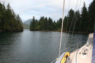
Columbia Cove, in Checleset Bay, is a well-protected inlet in the NE corner of the Brooks Peninsula. Very shallow and small, we wondered how three to four boats could share the inlet as suggested in the Waggoner’s Guide. Tired, we relaxed and enjoyed having the entire anchorage to our self: A first on the west side, typically a fishing boat would show up in the middle of the night but be gone by early morning.
Columbia Cove, a very sheltered anchorage
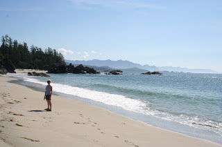
Until this trip we were unaware that Vancouver Island had Caribbean-type beaches. We’d experienced one at Hornby Island on Tribune Bay earlier and there are many of them and on the west coast of Vancouver Island. The difference, however, is that you’ll very likely be the only people on walking on them when you visit. No one else for miles.
Ah the beaches
We were very fortunate to have the experience of being the only two people on the beach.
Someone with a sense of humor turned this rock into a smoker?
Typical of many of the beaches we visited. Hard to get to so very quiet.
The Cruising Guide spoke of such a beach just on the outside of Columbia Cove. Taking the dinghy, we set off to find the trailhead leading to the beach. Marked by a white buoy, we trekked a short half-mile through a forest 0n a primitive path to the beach. It was spectacular! A long, fine-grain white sand beach with crystal blue skies was our reward! We walked down to a rocky outlook toward what looked like a crouching scout hunting in the distance. We had the entire beach to ourselves: No other person around. Well…That didn’t include bears! Having spent at least an hour looking around, we decided to return to the boat.
Maybe not so alone as we thought. This is a bear print below the tide line so it had visited earlier in the morning.
The return walk through the forest was faster than the one we’d made to the beach, and both of us were happy not to have had an encounter of a bear-kind.
The return walk through the forest was faster than the one we’d made to the beach, and both of us were happy not to have had an encounter of a bear-kind.
Later that afternoon, a 42’ powerboat, Rampage, entered our
hideaway Cove. Three generations were
aboard: Grandfather, two sons, and what
we assumed was his grandson. The
grandfather thanked us for our help telling him where the shallow areas were and
asked us if we’d like some salmon. We
said, “Yes,” and a few minutes later, the grandson, life jacket in place, rowed
it over to us in their dinghy!
Salmon delivery by 7 year old Charlie
Since we have five grandchildren, we were pretty pleased to see this little guy out in that dinghy by himself. Clearly, he’d spent lots of time on the water and was pretty proud of having “his own boat.” Pat thanked him for the fish, found out his name was Charlie, that he was seven years old, had been fishing for four days with his family, had caught at least one fish and was from Vancouver. We later saw him jump in the water and swim like a fish. That moment reminded us of our own family that was gathering that weekend on the beaches of California. We wished we could be there, but watching Charlie make us smile.
Since we have five grandchildren, we were pretty pleased to see this little guy out in that dinghy by himself. Clearly, he’d spent lots of time on the water and was pretty proud of having “his own boat.” Pat thanked him for the fish, found out his name was Charlie, that he was seven years old, had been fishing for four days with his family, had caught at least one fish and was from Vancouver. We later saw him jump in the water and swim like a fish. That moment reminded us of our own family that was gathering that weekend on the beaches of California. We wished we could be there, but watching Charlie make us smile.
Reluctant to leave Columbia Cove behind, we pulled
anchor. Rampage had left earlier that
morning to continue fishing, and we were going to move down the coast toward Scow
Bay in the Bunsby Islands.
Our next stop was only seven miles away and go exploring. Checleset Bay is a popular spot for kayaking with lots of protected coves and inlets to explore. Not long after we set our anchor, we had the kayaks in the water and set out.
Our next stop was only seven miles away and go exploring. Checleset Bay is a popular spot for kayaking with lots of protected coves and inlets to explore. Not long after we set our anchor, we had the kayaks in the water and set out.
Again, we thought we had the entirety of Scow Bay and the
Bunsby’s to ourselves. No sooner had I
said that, that I heard voices of two kayakers from the opposite end of the bay.
They were paddling toward us and we stopped for a conversation. The couple had taken a water taxi from
Walters Cove (aka Kyoquot Cove) and been dropped off on a nearby beach. They were going to kayak for a week and then be
picked up by the same water taxi later at a pre-determined location. This is a
very popular method to get to great kayaking locations on the west coast.
It really is a spectacular place to kayak or do anything
else for that matter. In the 1970’s, sea otters were reintroduced to the
Bunsby’s. We read that over 800,000
otters had been hunted in the north-Pacific-coastal waters during the late
1800’s, all but eliminating them. Today
there are a little over 3,000 sea otters in the area, 2,300 of which live in or
near these Islands.
Kayaking in Scow Bay
We used the dinghy to get in and out of the kayaks. Climbing into the kayak from the dinghy was a lot easier than from the sail boat
Clear night and sunset in the Bunsbys
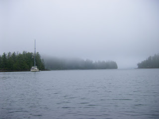
Early morning fog. There are many rocks and reefs passing through Checleset Bay so we had a later start to allow the fog to thin a little.
The local fishermen will tell you not all is charted.
We left the Bunsby’s the next morning, continuing to Walters Cove and the town of Kyoquot shared by two tribal communities. It had been raining during the night, and that morning we had heavy fog. We decided to wait a couple of hours for it to clear since the surrounding waters have lots of rocky shoals.
We departed the Bunsby’s around noon. The morning fog had thinned somewhat but we
both stood watch and were kept on our toes. We went slow and had only about nine miles to
go. The Cruising Guide warned that the entry into Walters Cove could be
confusing, a reverse “S” due to reefs. It was really important to follow the
red right returning rule.
En rout to Walters Cove with the reefs and rocks close by
En rout to Walters Cove with the reefs and rocks close by
Entering Walters Cove. Red and green markers are little confusing first time through because of the reverse S entrance around a couple of reefs
Pat went up to the bow of the boat to watch for the reefs, I kept my eyes on the chart plotter. Its a little like playing a video game with the boat. When we finally entered the harbor, we saw what we thought was the public wharf, only to have a lady come out to the end of the dock and tell us we were headed toward a shallow reef which WASN’T on our chart. Doing a hard reverse, she pointed us to the wharf on the opposite side of her location, we were relieved to tie up without damage.
Pat went up to the bow of the boat to watch for the reefs, I kept my eyes on the chart plotter. Its a little like playing a video game with the boat. When we finally entered the harbor, we saw what we thought was the public wharf, only to have a lady come out to the end of the dock and tell us we were headed toward a shallow reef which WASN’T on our chart. Doing a hard reverse, she pointed us to the wharf on the opposite side of her location, we were relieved to tie up without damage.
The Community of Kyuquot is like stepping back in time. This community is visited weekly by the MV
Uchuck III, which the locals nicknamed the “Upchuck”
because of the end result of the regular rough passages. A converted World
War II mine sweeper, it keeps many of the west coast communities supplied with
day to day necessities. The boat also carries tourists to destinations along
its route. A high point of the week is when the boat arrives late Thursday
afternoon and people from the surrounding communities line up in their boats or
walk down to the pier to pick up their orders.
Once inside the bay it is very protected
The town has no roads and this wood walk way runs around the bay
Looking back into Walters Bay
The local grocery store which is open from 1:00 p.m. – 5:00 p.m. Monday, Wednesday and Friday, is resupplied by the Uchuck III, so the best day to buy groceries is Friday afternoon. Luckily, a local had warned us that we’d be sharing the dock with the Vessel so we’d moved our board forward accordingly. We did, however, feel tied up in front of her, but happy to experience her arrival.
Tuamotu sharing the dock with the Uchuck.
This boat is a really big deal to these communities. In many cases it is the only way to get supplies.
The white tents are for the local market which is set up every time the Uchuck visits which is once a week.
Pat kayaking
The next morning the Uchuck cast off at 8:00 a.m. sharp, carrying passengers from Kyoquot to their next destination. After checking out the small grocery store Friday afternoon, we too cast off from the wharf, again leaving in light fog hoping it was clearer outside the inlet. Rather than take the more scenic and rocky coastline, we agreed to go further out in the Pacific. As we traveled, the fog lifted. Turning south again, we headed toward our destination Rugged Point Marine Park and Blue Lips or Dixie Cove (We hadn’t decided which), our next anchorage.
After about an hour-and-a-half motoring – again not enough
wind to sail – we pulled into a beautiful cove with two white-sand beaches. We anchored in about 28’ of water and took the
dinghy to go ashore. We were the only boat again: No other people. We found the trailhead to Rugged Point and
walked a short distance to the other side.
There was lots of driftwood and Pat found a couple of sand dollars to
add to the collection she had harvested in Tribune Bay.
Tuamotu in the distanceRugged park is a very popular stop but is not recommended for overnight anchorage in all but the most benign conditions
Part of Rugged Park
As we were walking back toward the opposite end of the beach, we saw some tracks that looked pretty fresh and big which we thought were cougar. After we’d hiked back to where we’d left the dinghy we saw signage of sightings of cougars in this area and read of a 2014 unprovoked attack on a visitor. .
Healthy Cougar tracks
Even bigger tracks
Rugged Point Marine Park is an exposed anchorage meaning there’s little protection from the wind. The conditions have to be very calm to comfortably spend the night. There was a Pacific swell getting into the bay and the possibility of North outflow wind in the evening. We decided to seek more protected anchorage in Blue Lips Cove, aka Petroglyph Cove (again, no pictures or etchings found) which was about four miles away.
Rugged Point Marine Park is an exposed anchorage meaning there’s little protection from the wind. The conditions have to be very calm to comfortably spend the night. There was a Pacific swell getting into the bay and the possibility of North outflow wind in the evening. We decided to seek more protected anchorage in Blue Lips Cove, aka Petroglyph Cove (again, no pictures or etchings found) which was about four miles away.
Pulling anchor around 7:00 p.m, about 45 minutes later we
were searching for the entryway which looking at the terrain was difficult to
spot. This cove has a 60’-wide entrance
and has a very small bay with steep sides:
Very protected, very pretty, very calm.
Dropping anchor about 8:00 p.m., we relaxed. If there was any wind out there, we wouldn’t
feel it.
The entrance was narrow and not easy to see but well worth the effort once inside
Anchored securely for the night
Blue Lips Cove was also our jump off point for our trip around to Esperanza Inlet and into Queen Cove, the next leg on our journey south. As we looked at the calendar, we were surprised and feeling remorseful that we were already six-weeks into our circumnavigation. The days were passing quickly! There was still so much to see and it felt like we were rushing, cutting out places we wanted to see so we could return to Seattle by the first part of September. We made a decision then, we needed to extend our return date.


1 comment:
Descriptions are excellent. Looking forward to the photographs.
Post a Comment